
Lidding Interstate 5 is not a new idea. This page explores the deep background behind Freeway Park, the Convention Center, and numerous other lid projects around the region.
Interstate 5
“It was with the Freeway, cutting through the very heart of the city, that Seattle began taking one of its wrong turns and started to lose its identity as a city.” — Paul Thiry, architect, quoted in the 1972 book “Seattle” by Nard Jones
When Interstate 5 was being designed in the late 1950s First Hill residents knew what they were in for. Predicting negative environmental effects and the consequences of being severed from Downtown, First Hill was the only neighborhood to mount a significant protest against the project. And despite being a vibrant community, the official freeway alignment was described as: “With few exceptions, this area contains older and less desirable buildings and is the beginning of the separation of the apartment house, clinic and residential area from the central business district — from Marion Street to Denny Way — this section will traverse an area that needs improvement in appearance“.
During the early planning, multiple mitigation efforts were launched. The Seattle Times reports that in 1956, the Seattle Transit Commission requested the State Highway Commission to include rail right-of-way in the freeway plans. However, “the state deemed that provision too expensive — at $15 million ($136 million in today’s dollars) — chump change next to what a rail route would cost today.”
The First Hill Improvement Club also enlisted the help of Seattle architects to request mitigation with landscape buffers, transit in the freeway right-of-way, or even tunneling through Downtown. Architect Paul Thiry, lead designer of the 1962 World’s Fair, suggested lids between Madison and University Streets and between Pike Street and Olive Way, citing the potential for aesthetic improvement and economic development opportunities. These early efforts did not succeed, and the Seattle portion of I-5 started construction in 1962 and finished in 1967.
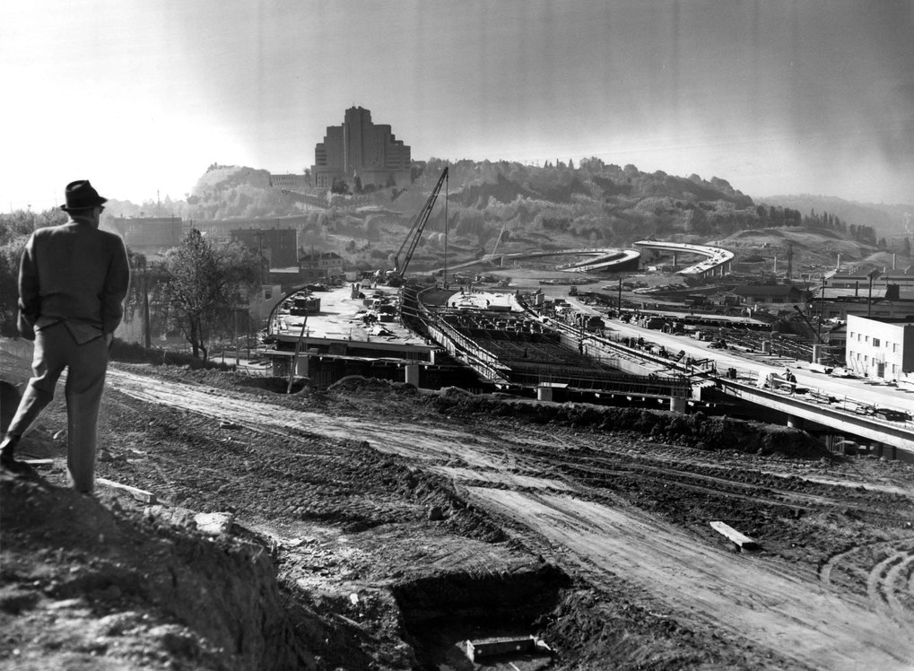
One compensation was the creation of Plymouth Pillars Park at the corner of Pike Street and Boren Avenue. The tiny park is named after four limestone columns that were reclaimed from the Plymouth Congregational Church, which was demolished on 6th Avenue to make way for the freeway. In 2005 the park was expanded across Boren Avenue with an off-leash dog area and now totals 0.6 acres.
Naramore Fountain
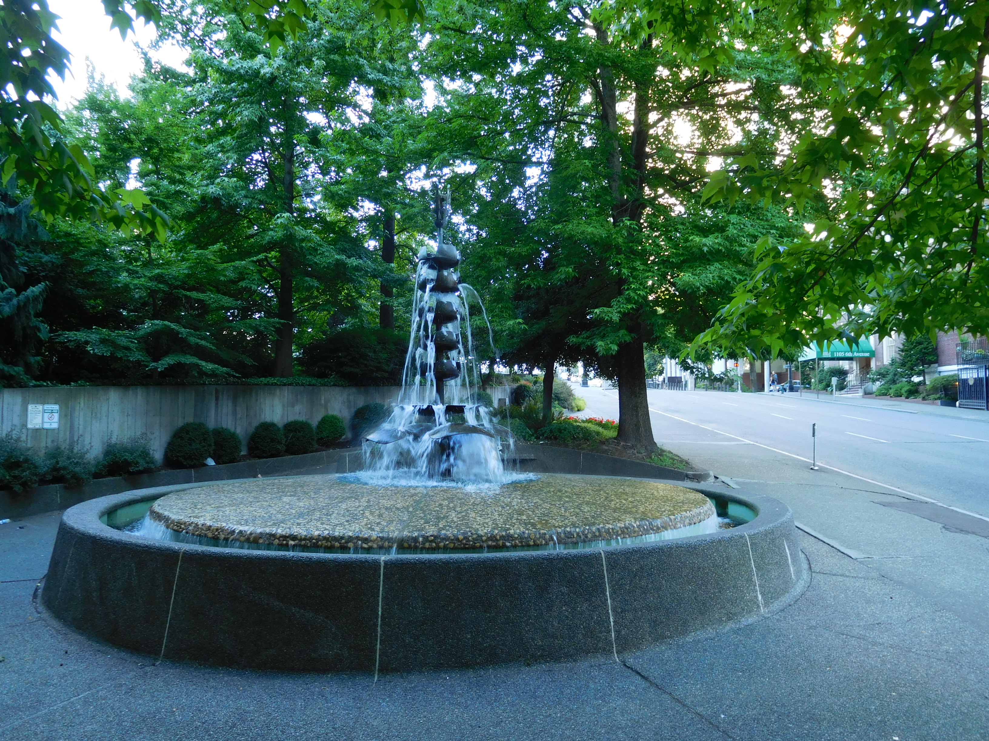
In 1967 the city sought to soften the impact of the freeway. Architect Floyd Naramore, co-founder of architecture firm NBBJ, donated $75,000 to build a small plaza on the southeastern corner of 6th Avenue and the Seneca Street off-ramp. The Naramore Fountain park still exists today on solid ground.
Another NBBJ co-founder, Perry Johanson, proposed extending this park north to the block bounded by 6th Avenue, Seneca Street, University Street, and the freeway. The city didn’t have funds immediately available, but at the time lawyer Jim Ellis (b. 1921) was organizing a series of King County bond propositions known as Forward Thrust to fund public improvements amid the region’s rapid population growth. Ellis observed the freeway construction from his office at the IBM Building on 5th Avenue, so he helped absorb Johanson’s proposal into the parks and recreation bond. The measured passed in 1968 with $2.8 million earmarked for the park.
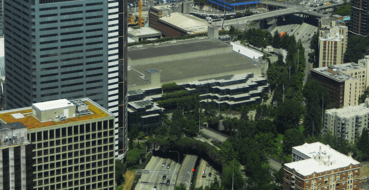
Freeway Park
After the bond passed, Ellis proposed extending the conceptual park across the freeway on the north side of Seneca Street. Seattle mayor Floyd Miller, the city council, the parks commission, and the planning commission all quickly signed on to the idea.
As the idea matured the concept included a partial lid on the south side of Seneca Street, between the Seneca Street overpass and a northbound off-ramp. The design was also extended eastward, above a 600-space public garage the city decided to build on the east side of the freeway using revenue bonds. The American Legion donated funds for a fountain on top of the garage.
The block originally intended for the park was privately owned, and as the lid park was being planned developer R.C. Hedreen was designing a 21 story office building and parking garage on the site. The city requested he shift his building to the northwest corner of the block and locate the parking underground. Recognizing the benefits, Hedreen agreed and also provided planters above the garage to make the new park appear seamless. The Park Place tower was completed in 1971 and had 95 percent occupancy throughout the decade despite a sluggish economy, demonstrating the benefit of the park’s proximity.

There was significant collaboration between agencies and private donors before the design team was even selected. State Governor Dan Evans offered support, and State Highway Director George Andrews secured funding for the lid; for the $5.5 million structure the federal government would pay 90 percent of the cost and the state would pick up the remaining 10 percent. The $4 million cost for the park itself mostly came from the Forward Thrust funding, and additional funding was secured through federal block grants and open space grants, federal urban arterial and interstate highway funds, and the State Interagency Committee for Outdoor Recreation. The newly formed King County Metro transit agency also funded a staircase to connect the park to 8th Avenue.
The $9.5 million total cost ($40 million in 2016 dollars) for the 4.9 acre park came to $45 per square foot at a time when Downtown land values were $50 per square foot. The city also secured the air rights from the state at no cost.
The design team, headed by landscape architects Lawrence Halprin and Angela Danadjieva, was selected in 1970 and included consultants in horticulture, irrigation, and structural, mechanical, and electrical engineering. They surveyed surrounding residents and found a preference for a mix of forest, lawns, and water like at Seattle’s Green Lake Park, Volunteer Park, and the Washington Arboretum. The designers also referenced an earlier Olmstead parks plan for Seattle and envisioned Freeway Park as one of many parts of a terraced green space leading to the Elliot Bay waterfront. A major design theme was contrast: Cars versus strollers, traffic noise versus water and wind, and hard concrete edges versus soft vegetative outlines. Ivy now overhangs the edges of the park and a “box garden” of trees cascades toward the freeway to enhance the perspective of the park from freeway motorists. With a 90 foot elevation difference between the lowest and highest points in the park, many stairways were required. Hundreds of trees and nearly 2,000 plants were incorporated.

After two years of construction the park opened in 1976 to great fanfare. Office workers, apartment residents, hospital patients, worshipers, retirees, families, and tourists regularly visited. “Out to Lunch” concerts encouraged people to eat outside in pleasant weather. It was a success, Ellis said, “…because it did not become a casualty of the war between freeway fighters and freeway lovers. This project did not suffer the attrition of lengthy lawsuits between environmentalists and developers.”
Pigott Memorial Corridor Extension
At first Freeway Park did not significantly reconnect Downtown with First Hill, the original impetus for the project, because a key land parcel was not available. But by 1984 the parcel was acquired by the city and an extension was created along the axis of University Street between 8th and 9th Avenues. Rising another 40 feet with a series of stairs and accessible ramps, the Pigott Memorial Corridor contains trees and a long water feature. It was designed by Angela Danadjieva’s own firm, Danadjieva & Koenig.
Washington State Convention Center
The need for a large convention center had dawned upon city and state leaders in the early 1970s, and in 1982 the state legislature authorized the creation a public non-profit corporation to design, construct, and operate a state-owned convention center in Seattle. The goal of the project was to attract new business to the Seattle area and provide event space for up to 10,000 attendees. After a public input process, a site over Interstate 5 and adjacent to Freeway Park was selected because it was closest to retail stores and hotels; the other options were Seattle Center and near the Kingdome stadium in Pioneer Square.
The Washington State Convention Center (WSCC) was constructed from 1985 to 1988 at a cost of $152 million ($308 million in 2016 dollars). It contains 370,000 square feet of exhibition, meeting, and retail space. The designers opted to bridge over 8th Avenue, rather than demolishing it, to use the overpass as an entrance to a 930 space garage. The facility also bridged over Convention Place for charter bus parking. Jim Ellis, who helped oversee the project on an advisory board, wrote, “…promised civic benefits of the project, such as lidding the freeway and expanding Freeway Park, are becoming realities.”
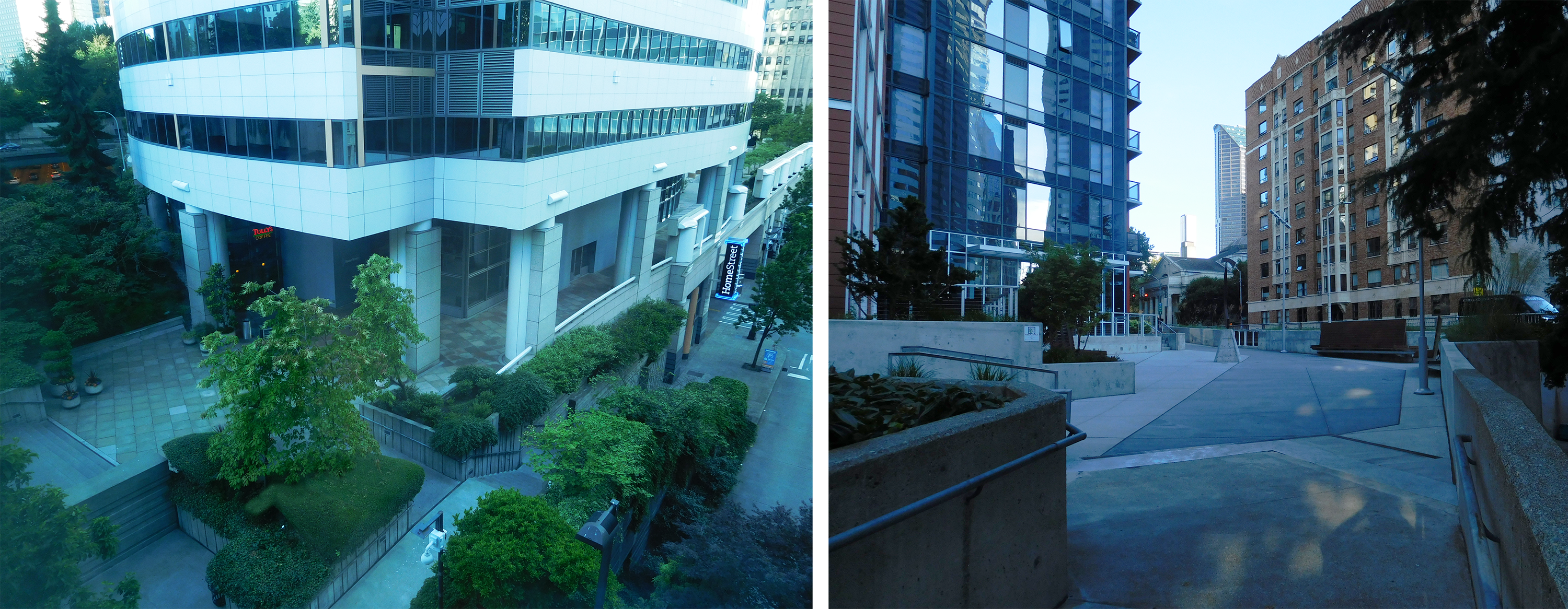
A plaza that functions as an extension of Freeway Park is located outside of WSCC Level 4. The plaza was built by the WSCC in exchange for greater development rights and is technically a privately owned public space, although the WSCC is a public entity. The plaza leads to a narrow walkway that wraps around the east side of the building to a park entrance at Pike Street. A new stairway entrance to the park was also created at Union Street.
Angela Danadjieva was also a design consultant for the WSCC project, and elements of Freeway Park are incorporated into the building. Blocky concrete forms and integrated plantings frame a water feature and an opening to the floor below on Level 4. The glass walls and ceilings on the south side of Level 4 also appear to tumble into the adjacent plaza.
In 1993 Ellis, then on the facility’s board of directors, began discussions with business and government leaders about expanding the facility to increase capacity. In partnership with private developers, a 100,000 square feet, $195 million expansion was built from 1999 to 2001 as the fourth level of a two-block hotel, retail, and parking complex bounded by Pike and Pine Streets and Seventh and Ninth Avenues. A large skybridge and truck ramp span over Pike Street to provide access between the two sections. Despite the expansion, growth in annual visitors has remained flat.
Freeway Park Expansions
Anticipating the development of the Convention Center, in 1983 designer Angela Danadjieva developed a master plan for the Interstate 5 airspace. It aimed to tie the Pigott Memorial Corridor and the Convention Center into a unified design with Freeway Park.

The plan envisioned partial lids on both sides of the Madison Street overpass and north of Pine Street; like the original park there would have been openings to the traffic below. A similar cascade of planter boxes would tumble towards drivers and soften the appearance of the trench’s vertical walls. This plan was never realized, but Freeway Park has expanded in small ways with adjacent private development.
North of Park Place is the Union Square complex, which has two office towers built in 1981 and 1989. During the second tower’s planning, developer Unico Properties paid for a small courtyard outside an upper lobby that creates another access point into Freeway Park and a connection to Union Square’s elevated retail courtyard on 6th Avenue.
In 2014 the Cielo apartment building at the corner of 8th Avenue and Seneca Street included a privately funded connection to Freeway Park between bottom of the Pigott Memorial Corridor and Seneca Street. The short walkway consists of some seating and planters and is open to the public.
Interstate 90 Lids
The Interstate 90 corridor between Seattle and the Eastside was completed in 1994. Moving east from the I-5 interchange, freeway traffic enters one of three 0.65 mile tunnels below the Mount Baker neighborhood. The western 1,500 feet of the tunnels are under the Mount Baker Lid, up to approximately South Yakima Street, and the rest is traditionally bored. The lid is bounded by South Massachusetts Street to the south and South Irving Street to the north. Ventilation stacks on the eastern side of the lid provide evidence about the traffic that lies below.

The Mount Baker Lid is about 10.3 acres and supports part of the 15.2 acre Sam Smith Park, which includes outdoor recreation areas for the adjacent Thurgood Marshall Elementary School. Other park features are tennis courts, a playground, and grass playing fields. Passing along the length of the lid and through the bored tunnel is part of a 10 mile long bicycle and pedestrian trail along Interstate 90 that connects Seattle and Bellevue. Two major arterial streets, 23rd Avenue South and Martin Luther King Junior Way South, pass over the lid.
Across Lake Washington on Mercer Island is the largest existing freeway lid in the country, Aubrey Davis Park. At 12.7 acres it stretches about a half mile over Interstate 90. It was motivated the mayor’s desire to not see, hear, or smell freeway traffic as it passed by residential neighborhoods. The rest of the corridor on Interstate 90 includes another lid at Luther Burbank park and extensive landscaping and sound walls.
State Route 520 Lids
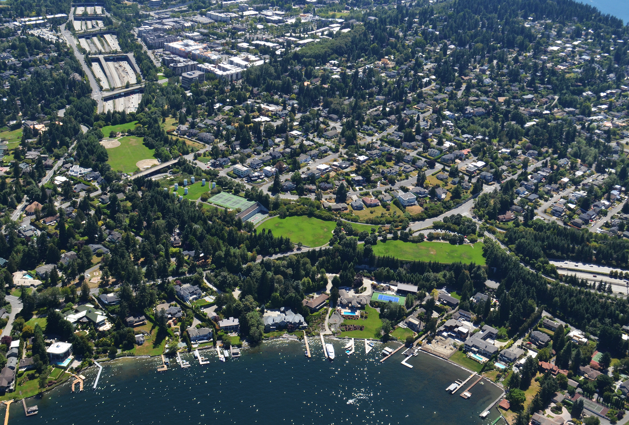
Most recently, in 2015 the Washington State Department of Transportation (WSDOT) completed three new lids over the rebuilt section of State Route 520 on the east side of Lake Washington. Running through the residential enclaves of Medina, Hunts Point, and Clyde Hill, the three lids are primarily widened overpasses on three north-south streets. All of them have unprogrammed open space primarily defined by lawns and two of them connect transit passengers to bus stops below within the freeway median. The three projects total about 6.1 acres.
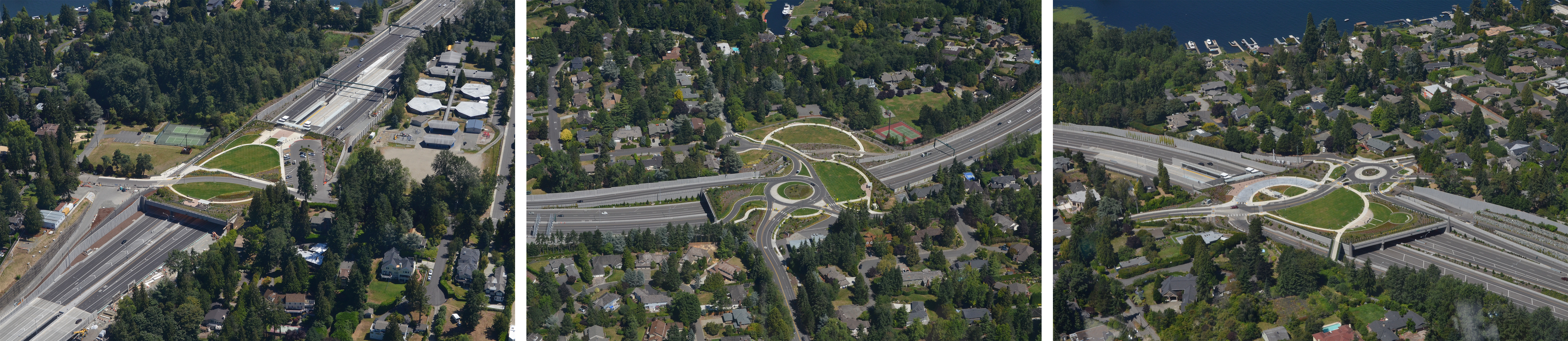
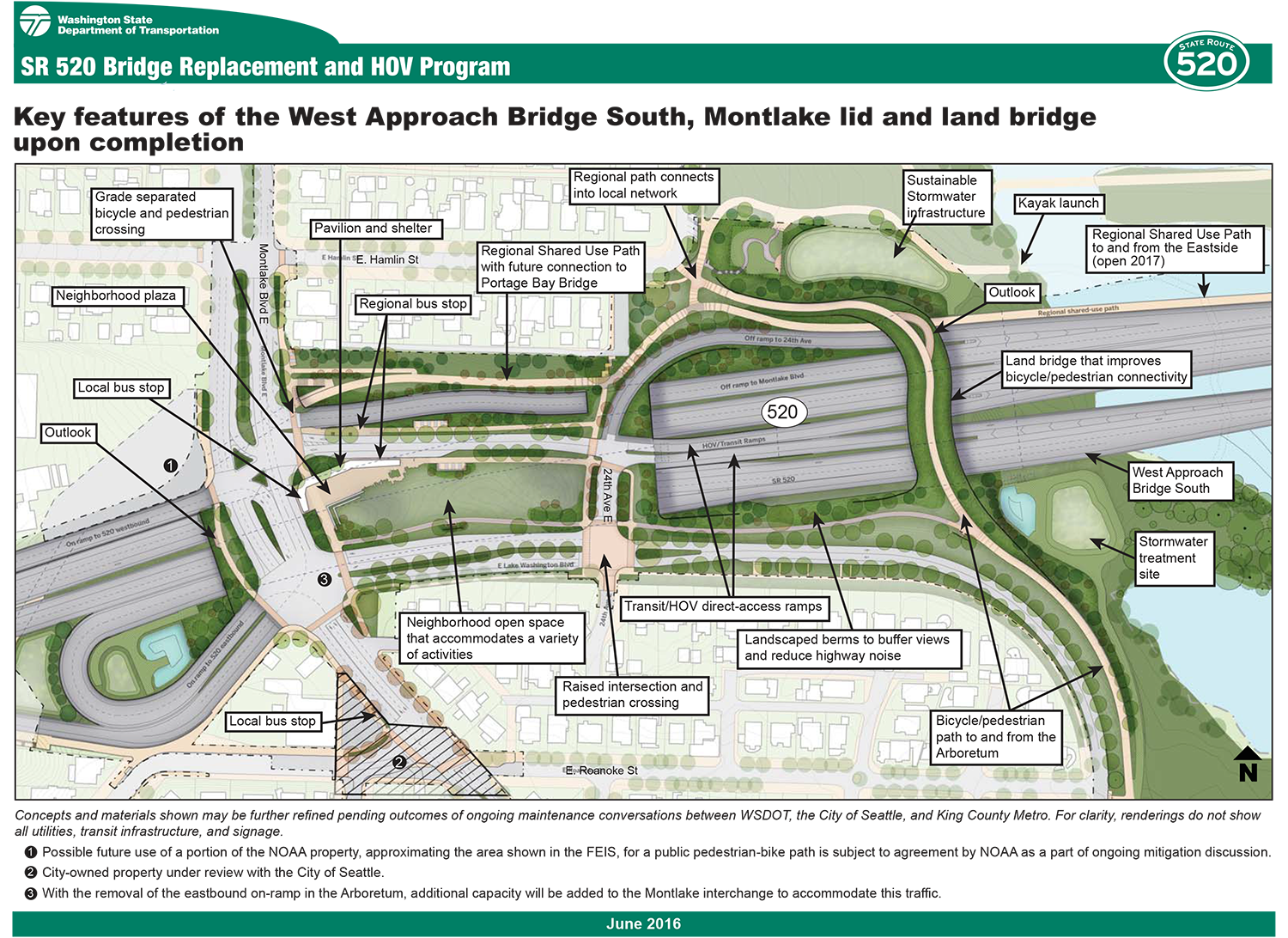
In addition, WSDOT conducted extensive community outreach where SR-520 will be rebuilt through Seattle and decided to design two more lids in the Montlake and Roanoke neighborhoods. The Montlake lid will serve a similar transit purpose and provide a bus stop, trail connections, and plantings while the Roanoke lid will be a small park. These two lids and rest of the connection to Interstate is planned to begin construction in 2018; see the Case Studies page for more information.
Convention Center Addition
Planning and design for the third expansion of the WSCC is underway. The primary site is bounded by 9th Avenue, Pine Street, Boren Avenue, and Olive Way; this is currently the site of King County Metro’s Convention Place bus station and layover area, and it will no longer be needed by 2021 when Link light rail begins operating to Northgate and increased train trips require removal of buses from the Downtown Seattle Transit Tunnel. The site is directly adjacent to Interstate 5, and the eastern corner of the facility is planned to cantilever over the Pike Street express ramp. The Convention Center will be requesting an air rights lease with WSDOT to accomplish this.
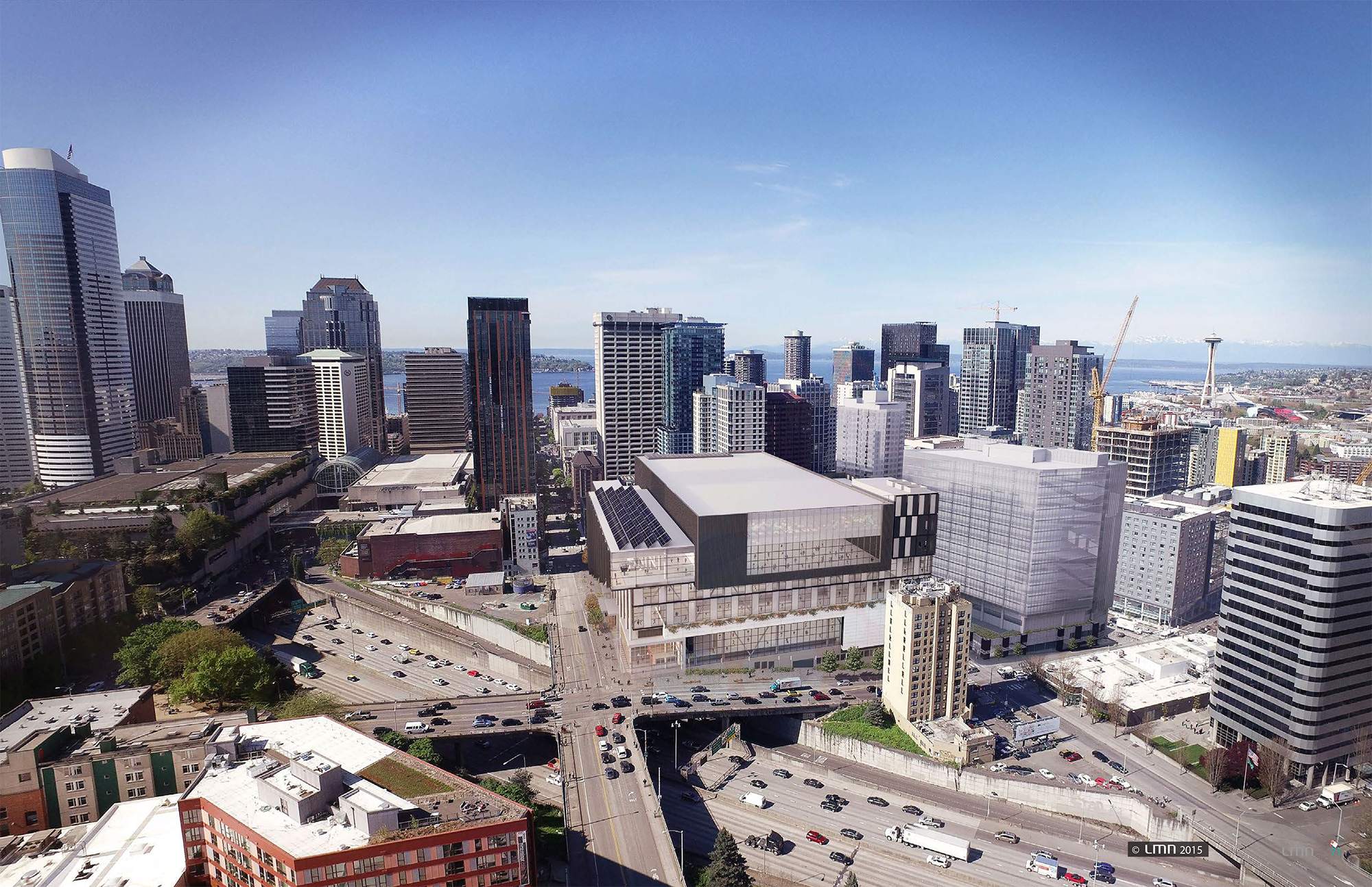
The 1.5 million square feet project, featuring conference, exhibition, and retail space, promises to greatly enhance the pedestrian experience on the western edge of the freeway. A newly activated street wall and small shops on Pine Street and Boren Avenue will help reduce the negative aspects of walking between two large pits in the urban landscape.
Advocacy from the Pike/Pine Urban Neighborhood Council has been successful in challenging the designers to create a building that anticipates additional lids over Interstate 5. In particular, a mid-sized retail space at the corner of Pine and Boren will help create a node and a new connection between Downtown and Capitol Hill. The Boren Avenue exterior wall has also been redesigned with large windows instead of blank exit stairwells.
The project’s $1.6 billion cost will also include private co-development across the street, between Olive Way and Howell Street, to help fund the project and increase the urban density of Downtown. The co-development will consist of a 29-story, 400-unit apartment building and a 16-story, 515,000 square feet office tower. The entire project anticipates beginning construction in 2017 and opening in 2020.
The Future
Freeway Park. The SR-520 lids. Expanding the Convention Center. These moments in history have coalesced into an energetic momentum for lidding more of Interstate 5 in Seattle. The time is now to begin laying the groundwork for completing the work of the leaders and experts that have come before. Bridging the rest of the gap in the Center City will finally heal the wound that the freeway has inflicted upon Seattle’s urban landscape. Closely studying the history of freeway lids in the region will enable Seattle to design lids that are successful for future generations.
